by Barani Chettiar | May 3, 2024 | Uncategorized
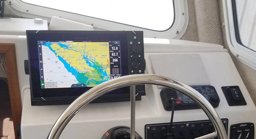
Choosing the Right Marine GPS System for Navigation and Positioning
Introduction: Importance of Marine GPS Systems
Navigating the open waters can be both exhilarating and challenging, especially when venturing into unfamiliar territories or facing adverse weather conditions. In such situations, having a reliable marine GPS (Global Positioning System) system is essential for ensuring accurate navigation, precise positioning, and overall safety on the water. In this article, we’ll explore the factors to consider when choosing the right marine GPS system to meet your navigation and positioning needs.
Overview of Navigation and Positioning Needs
Marine GPS systems serve as invaluable tools for boaters, providing real-time positioning information, route planning capabilities, and navigation assistance. Whether cruising along coastal waters, navigating through busy harbors, or embarking on offshore voyages, boaters rely on GPS systems to maintain course, avoid hazards, and reach their destinations safely. Additionally, marine GPS systems offer features such as waypoint marking, chart plotting, and AIS (Automatic Identification System) integration, further enhancing navigational capabilities on the water.
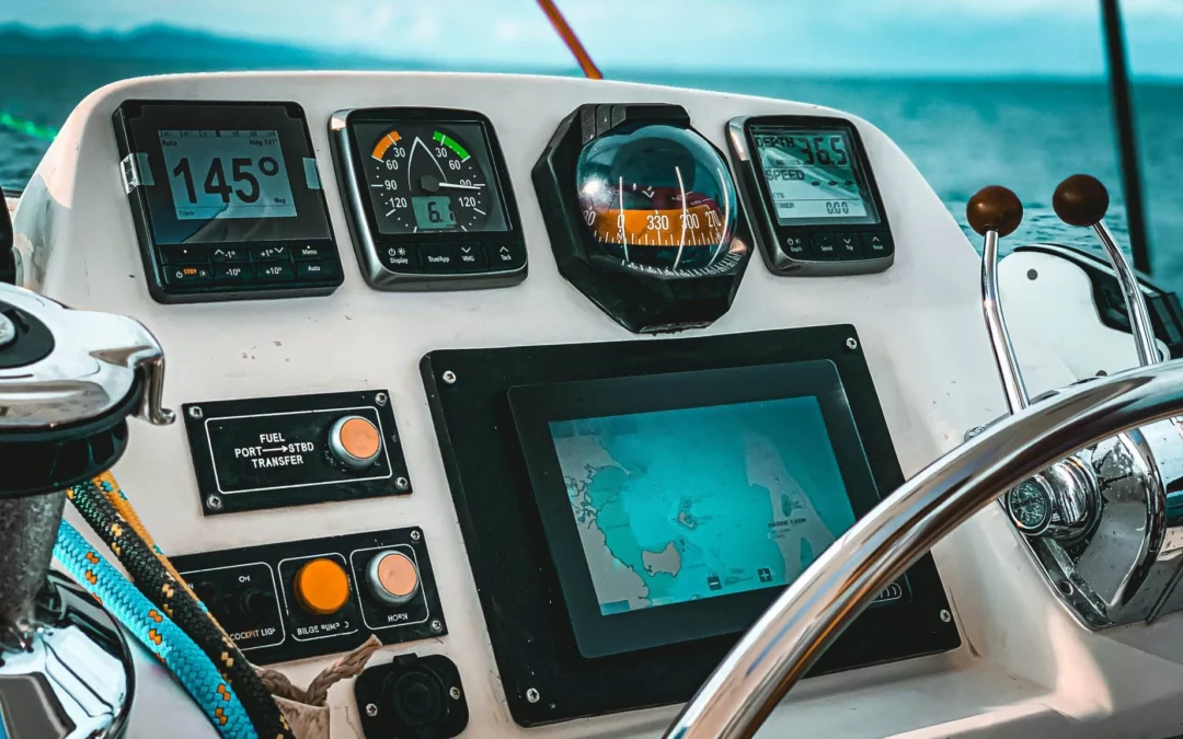
Types of Marine GPS Systems
When it comes to marine GPS systems, boaters have a choice between handheld and fixed-mount units, each offering unique advantages depending on the intended use and preferences.
- Handheld GPS Units: Portable and versatile, handheld GPS units are ideal for small vessels, kayaks, or recreational boating activities. They offer flexibility in usage, allowing boaters to carry them ashore or use them in multiple vessels.
- Fixed-Mount GPS Units: Fixed-mount GPS units are permanently installed on the boat’s dashboard or helm station. They typically offer larger screens, more advanced features, and seamless integration with other onboard electronics, making them suitable for larger vessels and professional maritime applications.
Key Features to Consider
When selecting a marine GPS system, several key features should be taken into account to ensure optimal performance and usability:
- Accuracy: Look for GPS systems with high-accuracy receivers capable of providing precise positioning data, even in challenging environments such as narrow channels or dense urban areas.
- Display Type: Consider the size, resolution, and readability of the display screen, especially in bright sunlight or low-light conditions. Touchscreen displays offer intuitive navigation, while button-operated interfaces may be preferable for use in wet or rough conditions.
- Connectivity Options: Evaluate the connectivity options offered by the GPS system, including compatibility with external sensors, chartplotter integration, and wireless connectivity for data sharing and software updates.
Factors Influencing Choice
Several factors may influence the choice of a marine GPS system, including:
- Budget: Determine your budget and prioritize features based on your navigation requirements and financial constraints.
- Vessel Size: Consider the size and type of vessel you own or operate, as well as the available space for mounting the GPS unit.
- Intended Use: Assess your intended use of the GPS system, whether for recreational cruising, fishing, sailing, or professional maritime activities, and select a system tailored to your specific needs.
Popular Marine GPS Brands
Some of the leading brands in the marine GPS industry include Garmin, Raymarine, Simrad, Lowrance, and Furuno. These reputable manufacturers offer a wide range of GPS systems catering to various budgets, preferences, and navigation requirements.
Installation and Maintenance Tips
Proper installation and maintenance are essential for ensuring the optimal performance and longevity of your marine GPS system:
- Mounting: Follow manufacturer guidelines for mounting the GPS unit in a location that provides a clear view of the sky and minimizes obstructions to satellite signals.
- Software Updates: Regularly update the GPS system’s firmware and navigation charts to ensure accuracy and compatibility with the latest data and features.
Conclusion: Importance of Choosing the Right System
In conclusion, selecting the right marine GPS system is crucial for safe and efficient navigation on the water. By considering factors such as accuracy, display type, connectivity options, budget, vessel size, and intended use, boaters can choose a GPS system that meets their navigation needs and enhances their overall boating experience. Whether cruising along coastal waters or embarking on offshore voyages, a reliable marine GPS system is an indispensable companion for navigating with confidence and peace of mind on the open seas.
by Barani Chettiar | May 2, 2024 | Uncategorized
Must-Have Navigational Instruments for Safe and Efficient Boating
Introduction: Importance of Navigational Instruments in Boating
Navigating the open waters can be both exhilarating and challenging, especially when faced with changing weather conditions, unfamiliar territories, and potential hazards. In such environments, having the right navigational instruments can make all the difference between a smooth voyage and encountering difficulties. In this article, we’ll explore some must-have navigational instruments essential for safe and efficient boating, highlighting their roles in ensuring precision, safety, and peace of mind on the water.
GPS Systems: Essential for Accurate Positioning
At the heart of modern boating navigation lies the Global Positioning System (GPS), a satellite-based navigation system that provides accurate positioning information anywhere on the globe. GPS systems, whether standalone units or integrated into multifunction displays, offer boaters real-time information about their exact location, speed, and course. With GPS, sailors can navigate confidently, plot routes, and navigate safely, even in unfamiliar waters or adverse weather conditions.
Marine Compass: Reliable Directional Guidance on Water
Despite the technological advancements in navigation, a traditional marine compass remains a crucial tool for boaters. Unlike GPS systems, which rely on satellite signals, a compass provides reliable directional guidance based on magnetic principles. Marine compasses are unaffected by electronic interference or signal loss, making them indispensable for maintaining course and orientation, especially in emergency situations or when navigating without power.
Depth Sounder: Prevents Running Aground in Shallow Waters
Navigating in shallow waters poses a significant risk of running aground, potentially causing damage to vessels and endangering passengers. To mitigate this risk, boaters rely on depth sounders, also known as echo sounders or fish finders. These instruments use sonar technology to measure water depth beneath the boat accurately. By displaying real-time depth readings, depth sounders allow boaters to navigate safely, avoid underwater obstacles, and identify suitable anchorage spots.
VHF Radio: Communication with Other Vessels and Emergency Services
Effective communication is paramount for safe boating, whether coordinating maneuvers with other vessels or calling for assistance during emergencies. Very High-Frequency (VHF) radios serve as the primary communication tool for boaters, offering reliable voice communication over short to moderate distances. VHF radios allow boaters to communicate with other vessels, harbor authorities, and emergency services, providing a vital lifeline in times of distress or when assistance is needed.
Radar System: Detects Objects and Obstacles in Low Visibility
In low visibility conditions, such as fog, darkness, or heavy rain, visual navigation alone may not be sufficient to detect nearby vessels, obstacles, or landmasses. Radar systems provide boaters with an additional layer of situational awareness by detecting and displaying objects in the surrounding environment. By emitting radio waves and analyzing their reflections, radar systems enable boaters to navigate safely, avoid collisions, and maintain awareness of their surroundings, even in adverse weather conditions.
Conclusion: Navigational Tools are Crucial for Safe Boating
In conclusion, navigational instruments are indispensable tools for ensuring safe and efficient boating operations. From GPS systems providing accurate positioning to marine compasses offering reliable directional guidance, depth sounders preventing groundings, VHF radios facilitating communication, and radar systems enhancing situational awareness, each instrument plays a vital role in boater safety. Whether embarking on a leisurely cruise or navigating through challenging waters, having the right navigational tools at hand is essential for a successful and enjoyable boating experience. By investing in quality navigational instruments and familiarizing oneself with their operation, boaters can navigate confidently, mitigate risks, and enjoy the freedom of exploring the open waters with peace of mind.
by Barani Chettiar | May 1, 2024 | Uncategorized
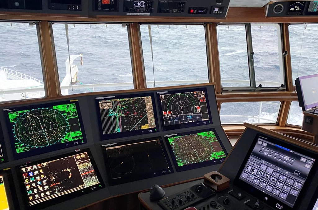
Key Features to Look for in a Marine Chartplotter for Commercial Vessels
In the intricate dance of commercial maritime operations, precision and accuracy are non-negotiable. Marine chartplotters have become the unsung heroes, providing captains and navigators with invaluable tools for efficient and safe navigation. In this blog post, we’ll explore the importance of marine chartplotters and delve into the key features that commercial vessel operators should consider when choosing the right one. From display specifications to integration capabilities, we’ll navigate through the essential elements that make a chartplotter a vital companion on the open seas.
Importance of Marine Chartplotters
Marine chartplotters are central to modern navigation, offering a digital representation of nautical charts and real-time vessel information. These devices contribute significantly to route planning, collision avoidance, and overall situational awareness. Their integration with Global Positioning System (GPS) technology has revolutionized marine navigation, providing precise location data and enhancing the safety and efficiency of commercial vessels.
Display Size and Resolution
The visibility and clarity of information on a chartplotter’s display are paramount for effective navigation. When choosing a chartplotter for commercial vessels, consider the size and resolution of the display. A larger screen allows for better readability, especially in challenging weather conditions. High resolution ensures that charts, symbols, and data are displayed with clarity, providing navigators with accurate information at a glance.
GPS Accuracy and Tracking Features
The heart of any chartplotter lies in its GPS capabilities. Accurate and reliable GPS positioning is crucial for plotting precise routes and avoiding potential hazards. Look for chartplotters with high-quality GPS receivers and consider models that support multiple satellite constellations for enhanced accuracy. Tracking features, such as breadcrumb trails and waypoint management, further contribute to effective navigation and route optimization.
Integration with Other Navigation Systems
In the interconnected world of marine navigation, the ability of a chartplotter to seamlessly integrate with other navigation systems is a key consideration. Look for chartplotters that support integration with radar systems, Automatic Identification System (AIS), and Electronic Chart Display and Information Systems (ECDIS). This integration ensures a comprehensive and unified navigational experience, allowing operators to make informed decisions based on a consolidated view of relevant data.
Weather and Traffic Information Integration
Commercial vessels operate in dynamic environments where real-time weather and traffic information is invaluable. Choose a chartplotter that can integrate weather updates and traffic data. Having access to current weather conditions and traffic patterns allows captains to make informed decisions, adjust routes, and ensure the safety of both the vessel and its crew.
Durability and Water Resistance
Marine environments can be harsh, exposing electronic equipment to challenging conditions such as salt spray and moisture. Select a chartplotter with a robust and durable design, built to withstand the rigors of maritime use. Look for devices with high water resistance ratings to ensure functionality even in wet and demanding conditions. Durability is a crucial factor in ensuring the longevity and reliability of the chartplotter in the demanding marine setting.
Conclusion: Choosing the Right Chartplotter for Safety
In the ever-evolving landscape of marine navigation, the right chartplotter can be a captain’s most trusted ally. To explore a comprehensive range of marine navigation equipment, including chartplotters, visit www.tecomart.co. When selecting a chartplotter for commercial vessels, prioritize features such as display size and resolution, GPS accuracy, integration capabilities, weather and traffic information integration, and durability. By choosing the right chartplotter, you’re not just investing in a device – you’re investing in the safety and efficiency of your commercial vessel operations. So, navigate wisely, and may your voyages be as smooth as the technology guiding your way.
by Barani Chettiar | Apr 30, 2024 | Uncategorized
Introduction: Navigating the Seas of Safety with Well-Maintained Equipment
Embarking on a maritime journey requires more than just a seaworthy vessel; it demands precision, accuracy, and a keen understanding of the importance of well-maintained marine navigational equipment. In this blog post, we’ll explore essential tips and practices for ensuring the longevity and reliability of nautical navigation equipment. Whether you’re a seasoned sailor or a novice at sea, understanding these maintenance and storage guidelines is crucial for a safe and successful voyage.
Regular Maintenance: Cleaning and Inspection Procedures
To guarantee the seamless operation of marine navigation equipment, regular maintenance is paramount. Begin with a routine cleaning schedule, ensuring that devices are free from salt deposits, debris, and other contaminants. Wipe down surfaces with a soft, damp cloth and use mild detergents to remove stubborn grime. Regular inspections should follow, checking for loose connections, frayed wires, or any signs of wear and tear. Promptly address any issues to prevent potential malfunctions during critical moments at sea.
Calibration Checks: Ensuring Accuracy of Instruments
Accurate readings are the lifeblood of marine navigation, making calibration checks a non-negotiable aspect of maintenance. Periodically calibrate your marine navigational equipment to guarantee precise measurements. Utilize certified calibration tools and, if needed, consult a professional to ensure the instruments meet industry standards. Reliable equipment not only enhances navigational accuracy but also contributes significantly to the safety of your maritime endeavors.
Proper Storage: Protecting from Moisture and Damage
The sea’s salty air can wreak havoc on marine navigation equipment, accelerating wear and corrosion. Proper storage is the key to protecting your instruments from moisture and potential damage. When not in use, store equipment in a dry and secure location. Invest in protective covers to shield devices from dust and humidity, and consider using moisture-absorbing products to maintain an optimal environment within storage spaces. These precautions may seem small, but they go a long way in preserving the functionality and lifespan of your nautical navigation equipment.
Battery Management: Maintaining Power Supply
The reliability of marine navigational equipment is directly tied to its power source. Regularly inspect batteries for signs of corrosion, leaks, or low voltage. Replace batteries as needed, adhering to the manufacturer’s guidelines. For devices with rechargeable batteries, follow proper charging practices and avoid overcharging, which can diminish battery life. A well-maintained power supply ensures that your equipment remains operational when it matters most, providing peace of mind during your maritime ventures.
Software Updates: Keeping Systems Up-to-Date
In the ever-evolving world of technology, software updates are crucial for the optimal performance of marine navigational equipment. Check for updates regularly and follow the manufacturer’s instructions for installing the latest firmware. Software updates often include improvements to functionality, bug fixes, and enhanced security features, ensuring that your equipment remains at the forefront of technological advancements. Stay informed about updates from your marine navigation equipment supplier, and take advantage of advancements to enhance the capabilities of your instruments.
Conclusion: The Anchor of Safety Lies in Proper Maintenance
In the realm of marine navigation, safety is paramount, and it begins with the proper maintenance and storage of navigational equipment. By adhering to a routine of regular cleaning, calibration checks, proper storage practices, vigilant battery management, and staying current with software updates, you fortify your vessel against the uncertainties of the open sea. Remember, a well-maintained and reliable navigation system is not just a convenience—it’s a necessity for a safe and successful maritime journey. So, whether you’re looking to buy marine radar or explore boat radar for sale, prioritize the upkeep of your equipment, and navigate the seas with confidence. Visit www.tecomart.co for a comprehensive selection of marine navigation equipment to enhance your nautical adventures.
by Barani Chettiar | Apr 29, 2024 | Uncategorized
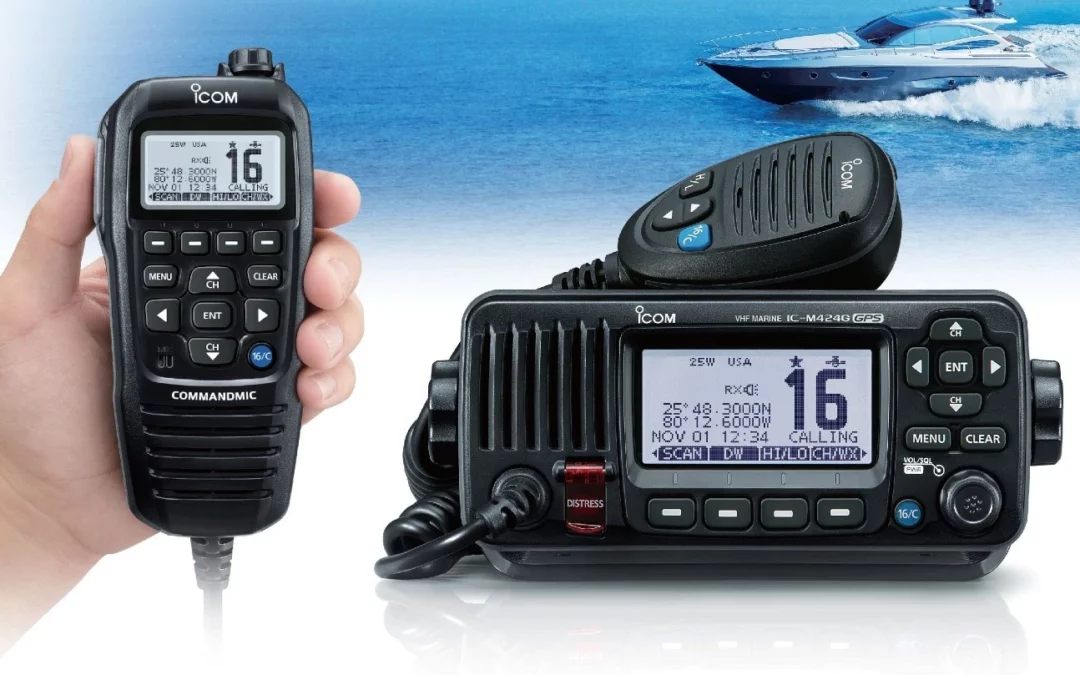
Introduction: Importance of Marine Radios with GPS/Chartplotter
In the intricate dance of marine navigation, having precise and real-time information is paramount. The integration of Global Positioning System (GPS) and chartplotter functionalities into marine radios has transformed the maritime landscape. This article explores the benefits of marine radios equipped with integrated GPS and chartplotter functions, highlighting their crucial role in enhancing safety, navigation efficiency, weather monitoring, communication, and overall cost-effectiveness.
Enhanced Safety: Immediate Location Identification in Emergencies
One of the primary advantages of marine radios with integrated GPS and chartplotter functions is the immediate identification of a vessel’s location in emergencies. In distress situations, such as collisions or unexpected weather events, the integrated GPS provides accurate coordinates, aiding search and rescue operations. This capability significantly reduces response time, enhancing the safety of both crew members and the vessel.
Navigation Efficiency: Real-Time Positioning for Accurate Navigation
Accurate navigation is the backbone of safe maritime travel. Marine radios with integrated GPS and chartplotter functions provide real-time positioning information, allowing sailors to navigate with precision. The combination of GPS and chartplotter features enables the display of the vessel’s position on electronic charts, ensuring that navigators can make informed decisions based on up-to-date and accurate data.
Weather Monitoring: Access to Weather Updates for Safe Sailing
Weather conditions can change rapidly at sea, posing challenges to navigation and safety. Marine radios with integrated GPS and chartplotter functions often come equipped with weather monitoring capabilities. This allows sailors to access real-time weather updates, including wind speed, wave height, and storm alerts. Armed with this information, sailors can make informed decisions about route adjustments, ensuring a safer and more efficient voyage.
Communication Ease: Seamless Communication with Other Vessels
Effective communication is essential for the safety and coordination of vessels at sea. Marine radios with integrated GPS and chartplotter functions streamline communication by combining essential navigation and communication tools in a single device. This integration allows for seamless communication with other vessels, harbor authorities, and maritime services. It promotes efficient collaboration, especially in busy waterways where clear communication is crucial.
Cost-Effective Solution: Combination of Essential Functions in One Device
Marine radios with integrated GPS and chartplotter functions offer a cost-effective solution by combining multiple essential functions into a single device. Rather than investing in separate GPS devices, chartplotters, and radios, mariners can benefit from an all-in-one solution. This not only reduces the equipment footprint on board but also simplifies installation, maintenance, and overall operational costs.
Conclusion: Marine Radios with Integrated GPS/Chartplotter Offer Numerous Benefits
In conclusion, marine radios equipped with integrated GPS and chartplotter functions have become indispensable tools for modern sailors. The seamless integration of navigation and communication features enhances safety, efficiency, and overall situational awareness at sea. The immediate identification of a vessel’s location in emergencies, real-time positioning for accurate navigation, access to weather updates, seamless communication with other vessels, and the cost-effective combination of essential functions make these devices a valuable asset for maritime professionals.
As technology continues to advance, marine radios with integrated GPS and chartplotter functions will likely play an even more significant role in shaping the future of maritime navigation. The benefits they offer contribute not only to the safety of individual vessels but also to the overall efficiency and sustainability of maritime travel, ensuring that sailors can navigate the vast oceans with confidence and precision.