
by Barani Chettiar | May 9, 2024 | Uncategorized
1. Importance of Accurate Timekeeping on the Water
In the realm of boating and maritime navigation, precise timekeeping is not just a matter of convenience; it’s a fundamental aspect of safety and efficiency. From coordinating maneuvers to calculating positions and monitoring tidal patterns, accurate timekeeping is essential for successful navigation on the water. Whether sailing across vast oceans or navigating through intricate waterways, boaters rely on marine clocks to keep track of time and ensure smooth and coordinated operations.
2. History of Marine Clocks
The history of marine clocks is intertwined with the history of seafaring itself. In the early days of maritime exploration, accurate timekeeping at sea was a formidable challenge. Traditional clocks were prone to inaccuracies caused by the motion of the vessel and fluctuations in temperature and humidity. However, the development of specialized marine clocks, such as chronometers and deck watches, revolutionized navigation by providing sailors with reliable timekeeping instruments capable of withstanding the rigors of life at sea.
3. Types of Marine Clocks – Chronometers, Deck Watches
Two primary types of marine clocks have been historically used for navigation:
- Chronometers: Chronometers are highly accurate mechanical timepieces specifically designed for maritime use. These precision instruments are equipped with robust mechanisms and housed in sturdy, shock-resistant cases to withstand the harsh conditions encountered at sea. Chronometers played a crucial role in determining longitude during the Age of Exploration and continue to be prized for their accuracy and reliability.
- Deck Watches: Deck watches are simpler timekeeping devices commonly used as secondary timepieces aboard ships. While not as precise as chronometers, deck watches provide reliable timekeeping for routine tasks and navigation calculations. They are typically mounted in prominent locations on the ship’s deck for easy reference by the crew.
4. Features and Benefits of Marine Clocks
Marine clocks offer several features and benefits tailored to the unique needs of boaters:
- Accuracy: Marine clocks are designed to maintain accurate timekeeping even in challenging maritime environments, ensuring reliable performance when navigating across vast distances or through adverse weather conditions.
- Durability: Built to withstand the rigors of life at sea, marine clocks are constructed from sturdy materials such as stainless steel or brass, with a shock-resistant design to withstand the vibrations and impacts encountered at sea.
- Visibility: Marine clocks feature clear, easy-to-read dials with luminous markings or backlighting for enhanced visibility in low-light conditions or during night-time navigation.
5. How to Choose the Right Marine Clock
When selecting a marine clock, consider the following factors to ensure it meets your specific needs:
- Accuracy: Choose a clock with a reliable timekeeping mechanism capable of maintaining accurate time over extended periods.
- Durability: Look for a clock constructed from robust materials such as stainless steel or brass, with a shock-resistant design to withstand the vibrations and impacts encountered at sea.
- Visibility: Opt for a clock with clear, legible markings and luminescent hands or backlighting for easy reading in all lighting conditions.
6. Maintenance Tips for Marine Clocks
To ensure the longevity and optimal performance of your marine clock, follow these maintenance tips:
- Regular Inspection: Periodically check the clock for signs of damage, corrosion, or malfunction, and address any issues promptly.
- Cleaning: Keep the clock clean and free from dirt, salt residue, and debris by wiping it down with a soft, damp cloth regularly.
- Calibration: If necessary, calibrate the clock according to manufacturer guidelines to maintain accurate timekeeping.
7. Conclusion: Marine Clocks Enhance Boating Experience
In conclusion, marine clocks are indispensable timekeeping instruments for boaters, providing accurate and reliable timekeeping essential for safe and efficient navigation on the water. From their historic role in maritime exploration to their continued use in modern-day boating, marine clocks embody the timeless tradition of precision and reliability at sea. By choosing the right marine clock and maintaining it properly, boaters can enhance their navigation experience and ensure smooth sailing on every voyage.
by Barani Chettiar | May 8, 2024 | Uncategorized
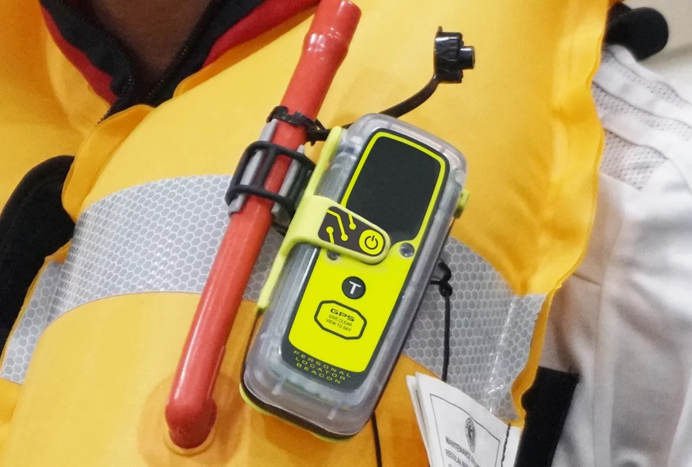
Introduction: Importance of PLBs in Maritime Emergencies
When facing the unpredictable and often treacherous conditions of the open sea, having access to reliable emergency signaling devices can make all the difference in ensuring a swift and effective rescue. Personal Locator Beacons (PLBs) are essential tools for maritime safety, providing individuals with a means to alert authorities to distress situations and facilitate their timely rescue. In this article, we’ll explore the functionality, benefits, regulations, and real-life success stories of PLBs in emergency situations at sea.
What are Personal Locator Beacons (PLBs)?
Personal Locator Beacons (PLBs) are compact, handheld distress signaling devices designed to transmit a distress signal on designated frequencies when activated. These devices are equipped with built-in GPS receivers, allowing them to transmit the user’s precise location to search and rescue authorities, significantly enhancing the chances of a successful rescue operation.
Functionality of PLBs in Distress Situations
In the event of an emergency at sea, activating a PLB triggers the transmission of a distress signal on internationally recognized frequencies. These signals are detected by satellite-based search and rescue systems, which relay the distress alert to ground stations and rescue coordination centers. Search and rescue teams are then dispatched to the precise location provided by the PLB to render assistance.
Benefits of Using PLBs at Sea
The use of PLBs offers several benefits in emergency situations at sea:
- Rapid Alerting: PLBs provide a rapid and reliable means of alerting search and rescue authorities to distress situations, even in remote or offshore locations where traditional communication methods may be unavailable.
- Precise Location: The integration of GPS technology in PLBs ensures accurate positioning information, expediting the response time of rescue operations and increasing the likelihood of successful outcomes.
- Portability and Versatility: PLBs are lightweight, portable, and easy to carry, making them suitable for use by individuals engaged in a wide range of maritime activities, from sailing and boating to fishing and kayaking.
Case Studies Highlighting Successful PLB Rescues
The effectiveness of PLBs in emergency situations at sea is exemplified through numerous real-life rescue stories where the timely activation of these devices has saved lives. From solo sailors stranded in remote oceans to fishermen lost at sea, PLBs have played a crucial role in alerting authorities to distress situations and guiding rescuers to their locations.
Regulations and Guidelines for Using PLBs
The use of PLBs is subject to regulations and guidelines established by international maritime organizations and regulatory authorities. These regulations outline requirements for the registration, maintenance, and operation of PLBs, as well as protocols for initiating and responding to distress signals.
Conclusion: The Vital Role of PLBs at Sea
In conclusion, Personal Locator Beacons (PLBs) play a vital role in emergency situations at sea, providing individuals with a lifeline to safety when facing distress situations on the water. By offering a rapid and reliable means of alerting search and rescue authorities to emergencies and providing accurate positioning information, PLBs significantly increase the chances of survival for individuals in peril at sea. Whether sailing across oceans or navigating coastal waters, having a PLB onboard can mean the difference between a successful rescue and a tragic outcome. As such, PLBs are indispensable tools for enhancing maritime safety and saving lives at sea.
by Barani Chettiar | May 7, 2024 | Uncategorized
Introduction:
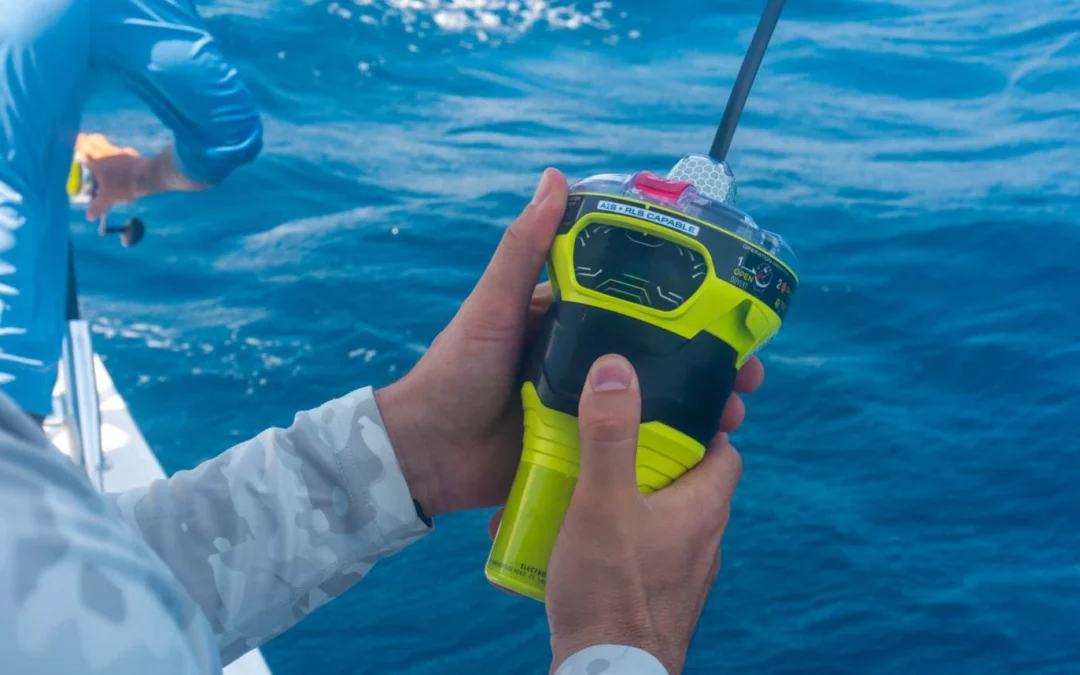
In the vast expanse of the world’s oceans, where unforeseen emergencies can arise at any moment, having reliable safety equipment onboard vessels is paramount. Among these lifesaving tools, the Emergency Position Indicating Radio Beacon (EPIRB) stands out as a beacon of hope, capable of alerting rescue authorities to distress situations and guiding them to those in need. In this article, we’ll explore the pivotal role of EPIRB in marine safety, from its definition and functioning to its regulatory requirements, benefits, limitations, and real-life success stories.
Definition of EPIRB:
An EPIRB is a distress signaling device designed to transmit a distress signal on designated frequencies when activated. These compact and rugged devices are equipped with built-in GPS receivers, allowing them to transmit the vessel’s precise location to search and rescue authorities, significantly enhancing the chances of a successful rescue operation.
Importance of Marine Safety Equipment:
Marine safety equipment plays a crucial role in safeguarding the lives of sailors, fishermen, and maritime adventurers alike. In the event of emergencies such as vessel sinking, fire, collision, or medical crises, having access to reliable safety equipment can mean the difference between life and death.
Brief History of EPIRB Technology:
The development of EPIRB technology can be traced back to the early 1970s when satellite-based search and rescue systems were first introduced. Over the decades, advancements in satellite communication and GPS technology have greatly improved the accuracy and effectiveness of EPIRBs in distress situations.
How EPIRB Works:
When activated, EPIRBs emit a distress signal on internationally recognized frequencies, which are detected by satellites in orbit. These satellites relay the distress signal to ground stations, which then notify rescue coordination centers of the distress situation and the vessel’s location. Search and rescue teams are then dispatched to the coordinates provided by the EPIRB to render assistance.
Regulations and Requirements:
EPIRBs are subject to international standards and legal obligations for maritime vessels. These regulations mandate the installation and maintenance of EPIRBs on certain types of vessels, including commercial ships, fishing vessels, and recreational boats, depending on their size and intended use. Compliance with these regulations is essential for ensuring the safety of maritime operations and facilitating timely rescue efforts.
Benefits of EPIRB:
The use of EPIRBs offers several benefits in distress situations. Firstly, EPIRBs provide a rapid and reliable means of alerting search and rescue authorities to emergencies, even in remote or offshore locations where traditional communication methods may be unavailable. Secondly, the integration of GPS technology in modern EPIRBs ensures accurate positioning information, expediting the response time of rescue operations and increasing the likelihood of successful outcomes.
Case Studies and Success Stories:
The effectiveness of EPIRBs in distress situations is exemplified through numerous real-life rescue stories where the timely activation of these devices has saved lives. From solo sailors stranded in remote oceans to fishing crews battling storms at sea, EPIRBs have played a crucial role in alerting authorities to distress situations and guiding rescuers to their locations.
Limitations and Considerations:
Despite their effectiveness, EPIRBs have certain limitations and considerations that users should be aware of. These include factors such as battery life and maintenance requirements, as well as the risk of false alarms and misuse. Proper training, regular testing, and adherence to manufacturer guidelines are essential for maximizing the reliability and effectiveness of EPIRBs.
Conclusion:
In conclusion, the Emergency Position Indicating Radio Beacon (EPIRB) serves as a vital tool for enhancing marine safety and saving lives at sea. By providing a rapid and reliable means of alerting search and rescue authorities to distress situations, EPIRBs significantly increase the chances of survival for sailors, fishermen, and maritime adventurers facing emergencies on the water. As an essential component of marine safety equipment, the use of EPIRBs is not only mandated by international regulations but also represents a proactive approach to ensuring the safety and security of maritime operations worldwide. Whether sailing across oceans or fishing in coastal waters, having an EPIRB onboard can mean the difference between a successful rescue and a tragic outcome.
by Barani Chettiar | May 5, 2024 | Uncategorized
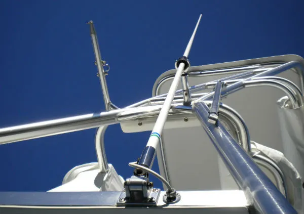
1. Importance of VHF Antennas for Marine Communication
In the vast expanse of the world’s oceans, effective communication is essential for safe and efficient navigation. VHF (Very High Frequency) antennas serve as the backbone of marine communication systems, enabling sailors to exchange vital information with other vessels, shore stations, and emergency services. These antennas facilitate the transmission and reception of VHF radio signals, allowing boaters to communicate navigational intentions, weather updates, and distress calls, thereby enhancing safety and coordination on the water.
2. Understanding the Difference Between Commercial and Recreational Use
Commercial and recreational boaters have distinct communication needs influenced by factors such as vessel size, operating environment, and regulatory requirements. Commercial vessels, such as cargo ships, fishing fleets, and passenger ferries, rely on robust communication systems to coordinate complex operations, comply with maritime regulations, and ensure the safety of crew and cargo. In contrast, recreational boaters may prioritize ease of use, affordability, and additional features such as AIS (Automatic Identification System) for enhanced situational awareness and collision avoidance.
3. Factors to Consider When Choosing an Antenna
Selecting the right VHF antenna requires careful consideration of several factors to ensure optimal performance and compatibility with the vessel’s requirements:
- Frequency Range: Ensure that the antenna is tuned to the VHF frequency band commonly used for marine communication (around 156-162 MHz).
- Gain: Consider the antenna’s gain, which determines its ability to transmit and receive signals efficiently over a specific range.
- Construction and Durability: Look for antennas constructed from high-quality materials such as fiberglass or stainless steel, capable of withstanding exposure to saltwater, UV radiation, and harsh weather conditions.
- Mounting Options: Evaluate the available mounting options, such as mast mounting, rail mounting, or deck mounting, to ensure compatibility with your vessel’s configuration.
- Cable Length: Choose an antenna with an appropriate cable length to reach your VHF radio without excessive slack or tension.
- Brand Reputation: Consider reputable brands known for their quality, reliability, and customer support services.
4. Types of Marine VHF Antennas Available
Several types of marine VHF antennas are available to suit different vessel types, operating conditions, and communication requirements:
- Fiberglass Whip Antennas: Durable and relatively affordable, fiberglass whip antennas are popular among recreational boaters for their versatility and ease of installation.
- Collinear Antennas: Collinear antennas feature multiple elements stacked vertically, offering increased gain and range for long-distance communication.
- Marine Band Antennas: Specifically designed for marine use, marine band antennas are optimized for VHF frequencies and often feature rugged construction and weatherproofing.
- Directional Antennas: Directional antennas, such as Yagi or Log-Periodic antennas, offer enhanced performance in specific directions, making them suitable for point-to-point communication or extending range in a particular direction.
5. Installation and Maintenance Tips
Proper installation and maintenance are crucial for maximizing the performance and longevity of marine VHF antennas:
- Location: Mount the antenna in a location that provides a clear line of sight to maximize signal coverage and minimize interference.
- Grounding: Ensure proper grounding to protect against static discharge and electrical interference.
- Cable Routing: Route antenna cables away from sources of electrical noise and avoid sharp bends or kinks that could degrade signal quality.
- Regular Inspection: Periodically inspect the antenna for signs of damage, corrosion, or loose connections, and address any issues promptly to prevent performance degradation.
6. Benefits of Selecting the Right Antenna
Choosing the right marine VHF antenna offers several benefits:
- Reliable Communication: A high-quality antenna ensures clear and consistent communication, enhancing safety and coordination on the water.
- Extended Range: Antennas with higher gain or directional capabilities can extend the range of communication, enabling communication over longer distances or in challenging conditions.
- Durability: Well-constructed antennas designed for marine environments withstand exposure to saltwater, UV radiation, and harsh weather conditions, ensuring long-term reliability and performance.
7. Conclusion: Making an Informed Decision
In conclusion, selecting the right VHF antenna is essential for ensuring reliable communication and safety on the water, whether for commercial or recreational use. By considering factors such as frequency range, gain, construction, mounting options, and maintenance requirements, boaters can choose an antenna that meets their specific communication needs and vessel requirements. Investing in a quality antenna and ensuring proper installation and maintenance will enhance the effectiveness and longevity of your marine communication system, providing peace of mind and confidence during every voyage.
by Barani Chettiar | May 4, 2024 | Uncategorized
1. Importance of VHF Antennas for Marine Communication
In the realm of maritime communication, VHF (Very High Frequency) antennas play a pivotal role in ensuring reliable and efficient communication between vessels, shore stations, and emergency services. These antennas facilitate the transmission and reception of VHF radio signals, allowing boaters to communicate critical information such as position, navigation intentions, and distress calls, thereby enhancing safety and coordination on the water.
2. Understanding the Difference Between Commercial and Recreational Use
Commercial and recreational vessels have distinct communication requirements, which influence the selection of VHF antennas. Commercial vessels, such as cargo ships, fishing boats, and passenger ferries, typically require robust and high-performance antennas capable of long-range communication and continuous operation in demanding maritime environments. On the other hand, recreational boaters may prioritize factors such as compact size, ease of installation, and affordability when choosing VHF antennas for leisurely cruising or fishing trips.
3. Factors to Consider When Choosing an Antenna
Several factors should be considered when selecting a marine VHF antenna:
- Frequency Range: Ensure that the antenna is compatible with the VHF frequency range used for marine communication (usually around 156-162 MHz).
- Gain: Consider the antenna’s gain, which determines its ability to transmit and receive signals efficiently over a specific range.
- Construction and Durability: Look for antennas constructed from high-quality materials such as fiberglass or stainless steel, capable of withstanding exposure to saltwater, UV radiation, and harsh weather conditions.
- Mounting Options: Evaluate the available mounting options, such as mast mounting, rail mounting, or deck mounting, to ensure compatibility with your vessel’s configuration.
- Cable Length: Choose an antenna with an appropriate cable length to reach your VHF radio without excessive slack or tension.
- Brand Reputation: Consider reputable brands known for their quality, reliability, and customer support services.
4. Types of Marine VHF Antennas Available
There are several types of marine VHF antennas available, each suited to different vessel types and communication requirements:
- Fiberglass Whip Antennas: Durable and relatively affordable, fiberglass whip antennas are popular among recreational boaters for their versatility and ease of installation.
- Collinear Antennas: Collinear antennas feature multiple elements stacked vertically, offering increased gain and range for long-distance communication.
- Marine Band Antennas: Specifically designed for marine use, marine band antennas are optimized for VHF frequencies and often feature rugged construction and weatherproofing.
- Directional Antennas: Directional antennas, such as Yagi or Log-Periodic antennas, offer enhanced performance in specific directions, making them suitable for point-to-point communication or extending range in a particular direction.
5. Installation and Maintenance Tips
Proper installation and maintenance are crucial for maximizing the performance and longevity of marine VHF antennas:
- Location: Mount the antenna in a location that provides a clear line of sight to maximize signal coverage and minimize interference.
- Grounding: Ensure proper grounding to protect against static discharge and electrical interference.
- Cable Routing: Route antenna cables away from sources of electrical noise and avoid sharp bends or kinks that could degrade signal quality.
- Regular Inspection: Periodically inspect the antenna for signs of damage, corrosion, or loose connections, and address any issues promptly to prevent performance degradation.
6. Benefits of Selecting the Right Antenna
Choosing the right marine VHF antenna offers several benefits:
- Reliable Communication: A high-quality antenna ensures clear and consistent communication, enhancing safety and coordination on the water.
- Extended Range: Antennas with higher gain or directional capabilities can extend the range of communication, enabling communication over longer distances or in challenging conditions.
- Durability: Well-constructed antennas designed for marine environments withstand exposure to saltwater, UV radiation, and harsh weather conditions, ensuring long-term reliability and performance.
7. Conclusion: Making an Informed Decision
In conclusion, selecting the right marine VHF antenna is essential for ensuring reliable communication and safety on the water, whether for commercial or recreational use. By considering factors such as frequency range, gain, construction, mounting options, and maintenance requirements, boaters can choose an antenna that meets their specific communication needs and vessel requirements. Investing in a quality antenna and ensuring proper installation and maintenance will enhance the effectiveness and longevity of your marine communication system, providing peace of mind and confidence during every voyage.