by Barani Chettiar | Jan 17, 2026 | Uncategorized
If you’ve recently started your journey into Amateur Radio, you’ve probably noticed one thing very quickly: cables are everywhere. Between your HF rig, your dual-band mobile, and your various antennas, the back of your desk can start to look like a bowl of spaghetti.
At Tecomart, we believe your radio experience should be about making contacts, not swapping cables. That’s where the Diamond Antenna series comes in.
What Is a Duplexer or Triplexer? (The Beginner’s Guide)
Think of these as smart traffic controllers for your radio signals.
-
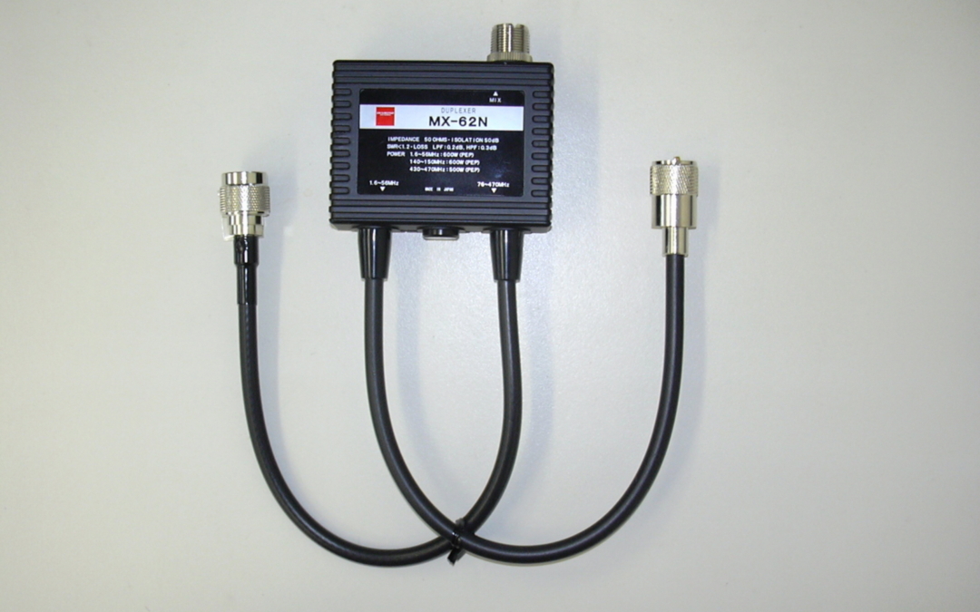
Duplexer (like the MX-62): Lets you use two different frequency ranges (for example, HF and UHF) on a single cable.
-
Triplexer (like the MX-2000): Allows three different frequency ranges to share one antenna or cable.
Diamond Antenna is world-renowned for making low-loss components, meaning they don’t weaken your signal as it passes through.
Finding the Right Match at Tecomart
1. The Standard Duplexers: MX-62 & MX-72 Series
These are perfect for hams running a standard HF + VHF/UHF setup.
-
MX-62M / MX-62N: Robust and powerful, handling up to 600W (PEP). If you use N-Type connectors for your UHF gear, the MX-62N is the best option for a cleaner signal.
-
MX-72 Series (A, D, H, N): Ultra-compact units offering up to 60dB isolation, ensuring that transmitting on one band does not interfere with another radio.
2. The Powerhouse Triplexers: MX-2000 & MX-3000
For operators who want maximum flexibility, a triplexer is a major station upgrade.
-
MX-2000 / MX-2000N: Supports 6m, 2m, and 70cm (HF/50/144/430MHz) through a single feed line, with power handling up to 800W.
-
MX-3000 / MX-3300: Designed for advanced operators, including support for the 1200MHz (23cm) band. These models use LPF/BPF/HPF filtering to keep signals cleanly separated.
3. For the Listeners: SS500 Splitter
If you are a Shortwave Listener (SWL) or scanner user, the SS500 is a wideband splitter (0.5–500MHz) that allows two receivers to share one antenna without noticeable signal loss.
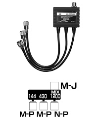 MX3300MN: HF 144/430/1200MHz
Which Connector Do I Need?
Tecomart stocks multiple connector configurations to match existing equipment:
-
M-P (PL-259): Standard for most HF and VHF radios.
-
N-P (N-Type): Preferred for UHF and 1200MHz operation due to significantly lower signal loss at higher frequencies.
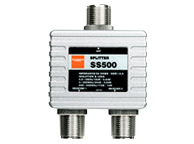 Splitter/Combiner for Recieving : SS500: 0.5 to 500MHz
Comparison Table
| Model |
Type |
Bands Supported |
Max Power |
| MX-62M |
Duplexer |
HF/6m + VHF/UHF |
600W |
| MX-72N |
Duplexer |
HF/VHF + UHF |
1000W (HF) |
| MX-2000N |
Triplexer |
6m + 2m + 70cm |
800W |
| MX-3000N |
Triplexer |
2m + 70cm + 23cm |
800W |
| SS500 |
Splitter |
0.5–500MHz |
Receiving Only |
Why Buy Diamond Antenna Products from Tecomart?
A poorly made duplexer or triplexer can cause high VSWR, potentially damaging expensive final transistors in your radio.
Diamond Antenna products are known for:
-
Minimal Loss: Less than 0.2dB in most models.
-
Built to Last: High-quality 5D-2VS coaxial tails and heavy-duty shielding.
-
Tecomart Support: Expert guidance to help you choose the right model.
Upgrade Your Station Today
Stop swapping cables and start operating more efficiently.
Visit www.Tecomart.co to see the full Diamond Antenna duplexer and triplexer inventory.
by Barani Chettiar | Dec 28, 2024 | Uncategorized
In the realm of marine electronics, the efficient management of data is paramount for smooth navigation and onboard functionality. NMEA multiplexers emerge as key players in this arena, providing a vital bridge between various onboard devices. But what exactly is an NMEA multiplexer?
Simplified Data Integration
At its core, an NMEA multiplexer is a device designed to streamline the integration of data from multiple NMEA (Navigational Marine Electronics Association) sources. These sources may include GPS receivers, depth sounders, chartplotters, and more. Instead of dealing with a maze of individual data streams, the multiplexer consolidates these inputs into a single, manageable data stream.
Enhanced Communication Between Devices
By serving as a centralized hub for data transmission, the multiplexer facilitates enhanced communication between onboard devices. This means that vital navigation and instrumentation data can flow seamlessly between devices, improving overall coordination and functionality.
Increased Efficiency and Accuracy
With data consolidation comes increased efficiency and accuracy. Rather than relying on disparate data streams that may be prone to errors or inconsistencies, the multiplexer ensures that all devices receive synchronized, up-to-date information. This not only enhances the precision of onboard systems but also streamlines decision-making processes for boaters.
Cost Savings on Additional Equipment
Another advantage of using an NMEA multiplexer is the potential for cost savings on additional equipment. Instead of requiring separate connections for each NMEA device, the multiplexer allows for the sharing of resources, reducing the need for duplicate hardware and wiring. This can result in significant savings in terms of both upfront costs and ongoing maintenance.
Improved Safety and Navigation Capabilities
Ultimately, the use of an NMEA multiplexer contributes to improved safety and navigation capabilities on board. By ensuring that critical navigation data is consistently and accurately transmitted between devices, the multiplexer enhances situational awareness and aids in making informed decisions while underway. Whether navigating coastal waters or venturing offshore, the reliability and efficiency of onboard systems are essential for a safe and enjoyable boating experience.
Conclusion: Why You Should Consider Using One
In conclusion, the benefits of using an NMEA multiplexer are clear. From simplified data integration and enhanced communication between devices to increased efficiency, cost savings, and improved safety and navigation capabilities, the multiplexer offers a host of advantages for boaters. Whether you’re outfitting a new vessel or upgrading an existing marine electronics system, considering the incorporation of an NMEA multiplexer is a decision that can greatly enhance the functionality and reliability of your onboard systems.
by Barani Chettiar | Dec 28, 2024 | Uncategorized
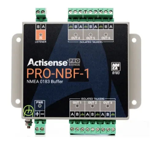
In the intricate web of marine electronics, NMEA networks stand as the backbone of communication, facilitating the exchange of critical data among onboard devices. Within this network, data buffering plays a vital role in ensuring the integrity and reliability of information transmission. Let’s delve into the significance of data buffering within NMEA networks and how it enhances efficiency and reliability.
Importance of Data Integrity: Prevents Data Loss
Data integrity is paramount in maritime operations, where accurate information can mean the difference between safe passage and disaster. By buffering incoming data packets, NMEA networks safeguard against data loss or corruption, ensuring that every piece of information reaches its destination intact.
Smooth Data Transmission: Ensures Continuous Flow
Smooth data transmission is essential for maintaining situational awareness and making informed decisions onboard. Buffers regulate the flow of data, preventing bottlenecks and ensuring a continuous stream of information between devices, even during peak usage periods.
Error Handling: Minimizes Communication Errors
Communication errors can disrupt navigation and compromise safety. NMEA buffers include error-handling mechanisms that detect and correct transmission errors, minimizing the risk of miscommunication and ensuring reliable data exchange between devices.
Increased Network Reliability: Reduces Network Congestion
Network congestion can hamper data transmission and impede critical operations. By temporarily storing and managing data packets, buffers alleviate network congestion, enhancing the reliability and efficiency of NMEA networks, especially in environments with multiple interconnected devices.
Scalability and Flexibility: Easy Integration with Various Devices
NMEA buffers offer scalability and flexibility, accommodating a wide range of devices and protocols. Whether it’s GPS receivers, chartplotters, depth sounders, or AIS transponders, buffers seamlessly integrate with diverse onboard instruments, fostering interoperability and adaptability.
Cost Efficiency: Saves on Hardware Expenses
In addition to their functional benefits, NMEA buffers offer cost efficiencies by reducing the need for redundant hardware. By consolidating data management functions within a single device, buffers streamline system architecture, minimizing equipment costs and optimizing resource allocation.
Conclusion: Buffers Enhance Efficiency and Reliability
In conclusion, NMEA buffers are indispensable components of marine electronics systems, enhancing efficiency and reliability in data transmission. By ensuring data integrity, facilitating smooth communication, handling errors, reducing network congestion, offering scalability and flexibility, and promoting cost efficiency, buffers play a crucial role in optimizing the performance of NMEA networks. As vessels navigate the vast expanse of the ocean, the reliability and efficiency afforded by NMEA buffers empower sailors to navigate with confidence, leveraging the full potential of their onboard systems to conquer the challenges of the maritime domain.
by Barani Chettiar | Sep 30, 2024 | Uncategorized
Introduction: Importance of Marine Radio Communication
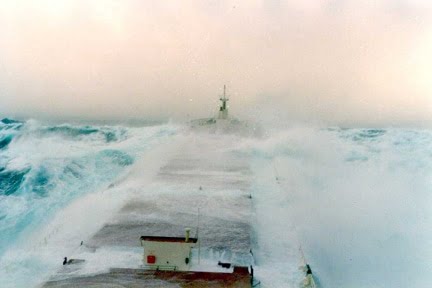
In the vast expanse of the open sea, reliable communication is the linchpin of maritime safety for commercial vessels. The effectiveness of marine radio communication can be compromised by various factors, with weather conditions posing a significant challenge. This article explores the impact of weather on marine radio equipment, the benefits of weatherproofing in enhancing durability and reliability, safety considerations during emergencies, the cost-effectiveness of weatherproofing, and maintenance tips to ensure the longevity of vital communication tools.
Weather Challenges: Impact on Equipment Functionality
Marine environments are unforgiving, with vessels often facing adverse weather conditions such as rain, saltwater exposure, high winds, and extreme temperatures. These environmental challenges can take a toll on the functionality of marine radio equipment. Moisture infiltration, corrosion, and exposure to saltwater can lead to short circuits, degraded performance, and, in extreme cases, complete equipment failure. Understanding the impact of weather on radio communication systems underscores the importance of proactive measures to mitigate these risks.
Benefits of Weatherproofing: Durability and Reliability
Weatherproofing marine radio equipment is a strategic solution to combat the detrimental effects of harsh environmental conditions. Weatherproofing involves the application of protective coatings, seals, and enclosures to create a barrier against moisture, salt, and other external elements. The benefits of weatherproofing extend beyond durability to ensure the long-term reliability of critical communication tools. Weatherproofed equipment stands resilient against the corrosive effects of saltwater, maintaining optimal functionality even in challenging maritime conditions.
Safety Considerations: Critical in Emergency Situations
During emergencies at sea, the reliability of marine radio communication can be a matter of life and death. Weatherproofed equipment provides a crucial layer of protection, ensuring that communication systems remain operational when needed most. In situations where vessels are exposed to heavy rain, storms, or rough seas, weatherproofing prevents water damage and helps maintain clear and consistent communication, facilitating timely coordination of rescue efforts and ensuring the safety of crew members.
Cost-Effectiveness: Long-Term Savings on Repairs
While the initial investment in weatherproofing may seem like an added expense, it is a strategic move that pays off in the long run. Weatherproofing marine radio equipment safeguards against the costly consequences of water damage and corrosion. By preventing premature wear and tear, weatherproofing reduces the frequency of repairs and equipment replacements, resulting in substantial cost savings over the operational lifespan of the vessel. The upfront investment in weatherproofing becomes a prudent financial decision for commercial vessels, offering a robust return on investment in terms of equipment longevity and operational reliability.
Maintenance Tips: Ensuring Longevity of Equipment
Beyond weatherproofing, regular maintenance practices are essential to ensure the longevity and optimal performance of marine radio equipment. Periodic inspections, cleaning, and testing should be integrated into the vessel’s routine maintenance schedule. Check for signs of wear, corrosion, or loose connections. Replace any damaged weatherproofing materials promptly, and conduct routine tests to verify the functionality of communication systems. Additionally, keep an eye on the manufacturer’s guidelines for specific maintenance recommendations to address the unique characteristics of each radio system.
Conclusion: Weatherproofing Essential for Marine Radio Equipment
In conclusion, weatherproofing is an indispensable measure for ensuring the reliability and longevity of marine radio equipment. The challenges posed by adverse weather conditions underscore the critical role of weatherproofing in preventing equipment damage and failure. The benefits of weatherproofing extend to safety considerations during emergencies, cost-effectiveness through long-term savings on repairs, and the overall durability of vital communication tools. Commercial vessels that prioritize weatherproofing contribute not only to the efficiency of their operations but also to the safety and well-being of their crew members in the unpredictable marine environment.
by Barani Chettiar | Aug 31, 2024 | Uncategorized
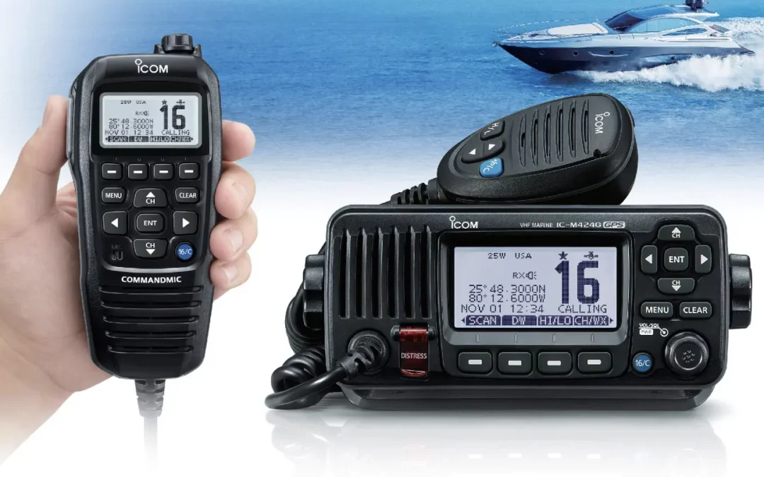
Introduction: Importance of Marine VHF Radios
Marine VHF radios are essential communication tools for boaters, providing a reliable means of communication while at sea. Whether it’s for routine communications with other vessels, obtaining weather updates, or sending distress calls in emergencies, marine VHF radios are indispensable for safe and efficient boating operations.
Basic Functions: Communication, Distress Calling, Weather Updates
At their core, marine VHF radios facilitate communication between vessels, harbors, and maritime authorities. They allow boaters to stay in touch with each other, coordinate movements, and request assistance when needed. Additionally, VHF radios are equipped with channels dedicated to distress calling (Channel 16) and weather updates (NOAA Weather Radio), ensuring that boaters have access to critical information at all times.
Advanced Features: DSC Capabilities, GPS Integration, Automatic Identification
Modern marine VHF radios come equipped with advanced features that enhance their functionality and safety capabilities. Digital Selective Calling (DSC) is one such feature that allows boaters to send distress signals with a single button press, automatically transmitting their vessel’s position to nearby vessels and rescue authorities. Many VHF radios also feature GPS integration, enabling automatic position reporting and accurate location tracking during distress situations. Additionally, automatic identification systems (AIS) allow vessels to exchange real-time information about their identity, position, and course, improving situational awareness and collision avoidance.
Safety Applications: Man Overboard Alarms, Emergency Channels
Safety is paramount at sea, and marine VHF radios play a crucial role in ensuring the well-being of boaters. Many VHF radios are equipped with man overboard alarms, which trigger an alert if a crew member falls overboard, facilitating quick and effective rescue operations. Emergency channels, such as Channel 16, provide a dedicated frequency for distress calls, enabling boaters to quickly summon assistance in emergencies.
Networking Capabilities: AIS Integration, Inter-Vessel Communication
Marine VHF radios also facilitate networking and communication between vessels. AIS integration allows boaters to receive real-time information about nearby vessels, including their identity, position, and course, helping to avoid collisions and navigate safely in congested waters. Inter-vessel communication capabilities enable boaters to communicate directly with other vessels, facilitating coordination and collaboration during joint operations or emergencies.
Maintenance and Care Tips: Antenna Checks, Battery Monitoring
To ensure the reliability and effectiveness of marine VHF radios, regular maintenance and care are essential. Boaters should regularly inspect their VHF antennas for signs of damage or corrosion, as damaged antennas can impair communication range and signal quality. Additionally, monitoring the battery status and ensuring adequate power supply is crucial to ensure that the radio remains operational when needed most.
Conclusion: Essential Tool for Safe Boating Communication
In conclusion, marine VHF radios are essential communication tools for boaters, providing reliable communication, safety features, and networking capabilities that are vital for safe and efficient boating operations. With advanced features such as DSC capabilities, GPS integration, and AIS networking, VHF radios offer boaters enhanced situational awareness and communication capabilities, improving safety and coordination on the water. By maintaining and caring for their VHF radios and utilizing their advanced features effectively, boaters can ensure a safer and more enjoyable boating experience for themselves and their crew. For those in need of a good VHF radio, consider a trusted supplier like Tecomart, which offers an extensive range of ICOM and Standard Horizon marine products.